|
|
||||
| ||||
Pearl Harbor: Where History Forever Changed Paradise |
||||
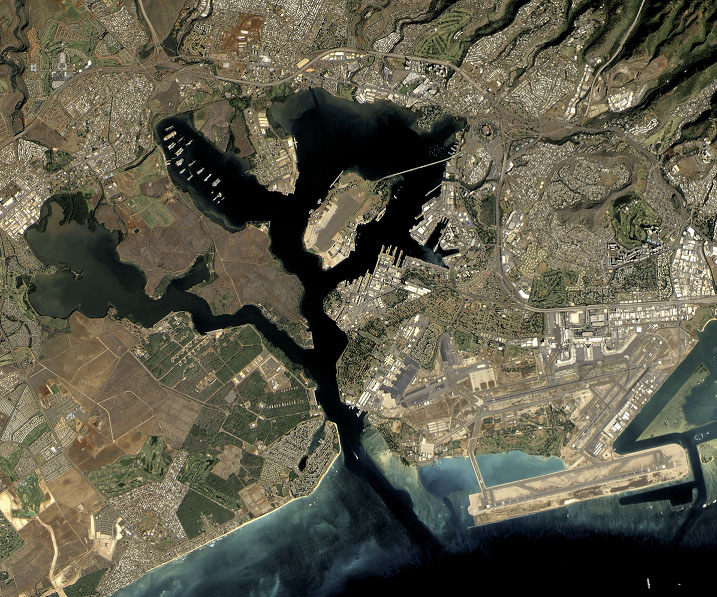
The morning sun casts long shadows across the tranquil waters of Pearl Harbor, its golden rays dancing on the surface of what was once called Wai Momi - "Pearl Waters" - by Native Hawaiians. Today, this sheltered inlet on Oahu's southern coast stands as one of America's most sacred historical sites, where the echoes of December 7, 1941, continue to resonate through time. Sacred Waters, Sacred GroundLong before Pearl Harbor became synonymous with a date that would "live in infamy," these waters held deep significance for the Hawaiian people. The harbor's name derives from the pearl oysters that once flourished in its depths, creating lustrous treasures that Native Hawaiians would dive to collect. The natural deepwater port, protected by coral reefs and surrounded by fertile lands, made this location strategically important for centuries. The harbor's transformation began in the late 1800s when the United States recognized its military potential. By 1908, Congress had authorized the construction of Pearl Harbor Naval Base, forever altering this peaceful inlet into America's most important Pacific naval installation. A Day That Changed EverythingDecember 7, 1941, dawned clear and calm across Oahu. Sailors aboard the ships moored in Battleship Row were enjoying a quiet Sunday morning, many still in their bunks or preparing for church services. The tropical breeze carried the scent of plumeria and the distant sound of church bells from Honolulu. At 7:48 AM, that serenity shattered. The first wave of Japanese aircraft appeared over the Koolau Mountains, their engines creating an ominous drone that would forever change the course of world history. In just under two hours, the surprise attack would claim 2,403 American lives, wound 1,178 others, and thrust the United States into World War II. The USS Arizona bore the brunt of the devastation. When a 1,760-pound armor-piercing bomb penetrated her forward ammunition magazine, the massive explosion lifted the 608-foot battleship out of the water. In mere moments, 1,177 sailors and Marines lost their lives - nearly half of all Pearl Harbor casualties. Stories of Heroism in ParadiseAmid the chaos and destruction, countless acts of heroism emerged. Doris "Dorie" Miller, a mess attendant aboard the USS West Virginia, carried wounded sailors to safety and manned an anti-aircraft gun despite having no training on the weapon. His courage would later earn him the Navy Cross, making him the first African American to receive this honor during World War II. Across the harbor, doctors and nurses at the nearby Tripler Army Medical Center worked tirelessly to treat the wounded, transforming the hospital into a scene of organized chaos where medical professionals saved hundreds of lives through sheer determination and skill. The Memorial Experience
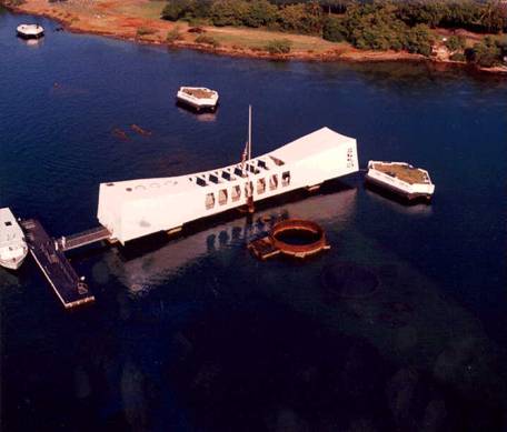
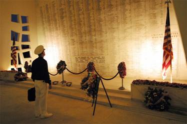
Today, Pearl Harbor Historic Sites encompasses four major attractions that tell the complete story of December 7th and its aftermath. The USS Arizona Memorial, a gleaming white structure that spans the sunken battleship, serves as both tomb and tribute to those who perished. Visitors often describe the profound silence that falls over them as they stand above the final resting place of 1,102 sailors and Marines who remain entombed within the ship's hull. The memorial's design, conceived by architect Alfred Preis, reflects both the initial defeat and ultimate victory of American forces. Its sagging center represents the country's low point on December 7th, while the raised ends symbolize America's eventual triumph and renewed strength. Oil still seeps from the Arizona's fuel tanks, creating an iridescent sheen on the water's surface. Locals call these "black tears" - a poignant reminder that the ship continues to weep for her lost crew more than eight decades later. 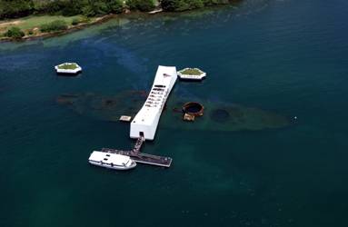 Another view of the Arizona Memorial Beyond the ArizonaThe USS Missouri, known as the "Mighty Mo," provides a powerful bookend to the Pearl Harbor story. This Iowa-class battleship, now permanently moored just yards from the Arizona, served as the site of Japan's formal surrender on September 2, 1945. Standing on her deck where General MacArthur accepted the Japanese surrender documents offers visitors a tangible connection to both the war's beginning and end. The USS Bowfin Submarine Museum and Park allows guests to explore life aboard a World War II submarine, while the Pearl Harbor Aviation Museum houses an impressive collection of vintage aircraft, including some that fought in the Pacific Theater. A Living MemorialPearl Harbor represents more than a historical site - it's a living memorial where past and present intersect. The roughly 1.8 million annual visitors come not just to learn about military history, but to pay their respects and reflect on the cost of freedom. The harbor remains an active military installation, with modern warships sharing the waters with their historic predecessors. This juxtaposition serves as a powerful reminder that the lessons of Pearl Harbor continue to shape American defense strategy and international relations. Planning Your Visit to Sacred GroundVisiting Pearl Harbor requires advance planning, as all bags and personal items must be stored before entering the memorial grounds. The reverent atmosphere encourages quiet reflection, and photography restrictions help maintain the site's dignity. The experience typically begins at the Pearl Harbor Visitor Center, where exhibits provide historical context before visitors board Navy launches for the short journey to the Arizona Memorial. The 23-minute documentary film, featuring actual footage from the attack, prepares visitors for the emotional impact of standing above the sunken battleship. Lessons Carved in StoneThe words inscribed on the Arizona Memorial's marble wall - listing the names of all who perished aboard the ship - serve as more than a roll call of the dead. They represent a commitment to remember, to honor, and to ensure that the sacrifices made in these waters continue to have meaning. Pearl Harbor stands as testament to the resilience of the human spirit and the price of freedom. In this place where paradise met tragedy, where ordinary people became heroes, and where a nation's resolve was forever strengthened, visitors find not just history, but inspiration. The harbor's waters remain as blue and tranquil as they were that Sunday morning in 1941, but they now carry within them the weight of memory and the power of remembrance. Here, in this sacred corner of Oahu, the past lives on, ensuring that December 7, 1941, will indeed live in infamy - and that those who made the ultimate sacrifice will never be forgotten. |
||||
|
Oahu
* Maui
* "Big
Island" of Hawaii * Kauai
*
Molokai * Lanai
© 2007 - 2026 USTropics.com
- All rights reserved.
|
||||